


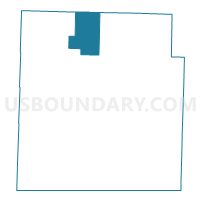
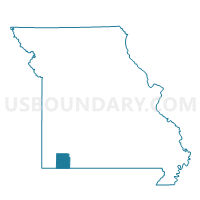
Kings Prairie Voting District, Barry County, Missouri
About
Outline

Summary
| Unique Area Identifier | 607070 |
| Name | Kings Prairie Voting District |
| County | Barry County |
| State | Missouri |
| Area (square miles) | 29.33 |
| Land Area (square miles) | 29.29 |
| Water Area (square miles) | 0.04 |
| % of Land Area | 99.86 |
| % of Water Area | 0.14 |
| Latitude of the Internal Point | 36.87500510 |
| Longtitude of the Internal Point | -93.86274310 |
Maps

Graphs
Select a template below for downloading or customizing gragh for Kings Prairie Voting District, Barry County, Missouri


Neighbors
Neighoring Voting District (by Name) Neighboring Voting District on the Map
- Forest Park Voting District, Lawrence County, MO
- McDowell Voting District, Barry County, MO
- Monett Voting District, Barry County, MO
- Pleasant Ridge Voting District, Barry County, MO
- Purdy Voting District, Barry County, MO
- Spring River Voting District, Lawrence County, MO
Top 10 Neighboring County Subdivision (by Population) Neighboring County Subdivision on the Map
- Pierce township, Lawrence County, MO (6,586)
- Monett township, Barry County, MO (6,457)
- Spring River township, Lawrence County, MO (2,199)
- Purdy township, Barry County, MO (1,972)
- Kings Prairie township, Barry County, MO (971)
- McDonald township, Barry County, MO (853)
- Pleasant Ridge township, Barry County, MO (486)
- McDowell township, Barry County, MO (288)
Top 10 Neighboring Place (by Population) Neighboring Place on the Map
Top 10 Neighboring Unified School District (by Population) Neighboring Unified School District on the Map
- Monett R-I School District, MO (12,231)
- Purdy R-II School District, MO (3,365)
- Verona R-VII School District, MO (2,395)
Top 10 Neighboring State Legislative District Lower Chamber (by Population) Neighboring State Legislative District Lower Chamber on the Map
Top 10 Neighboring State Legislative District Upper Chamber (by Population) Neighboring State Legislative District Upper Chamber on the Map
Top 10 Neighboring 111th Congressional District (by Population) Neighboring 111th Congressional District on the Map
Top 10 Neighboring Census Tract (by Population) Neighboring Census Tract on the Map
- Census Tract 4704, Lawrence County, MO (6,665)
- Census Tract 9602, Barry County, MO (6,418)
- Census Tract 9603, Barry County, MO (6,400)
- Census Tract 9601, Barry County, MO (6,127)
- Census Tract 4703, Lawrence County, MO (5,445)